Key Points
- Tropical Cyclone Kirrily was downgraded to a category one, a few hours after making landfall
- It approached the coast as a severe category three system and slipped to a category two just before making landfall.
- The Bureau of Meteorology said there could still be strong winds and heavy rain as the cyclone makes its way inland.
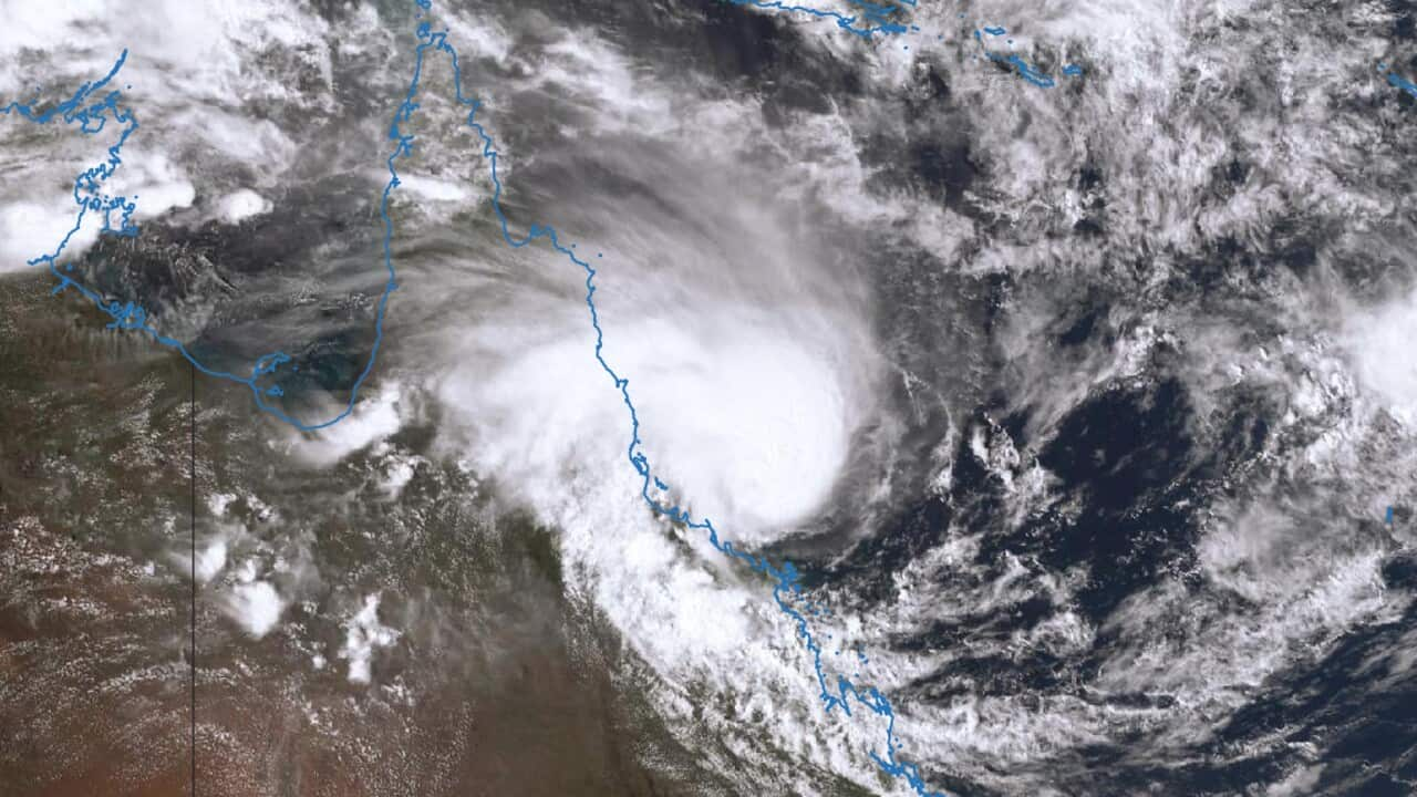
Tropical Cyclone Kirrily is expected to "rapidly decay" after crossing the Queensland coast northwest of Townsville as one of the most powerful systems seen in the north.
However, the Bureau of Meteorology says it could still bring strong winds and heavy rain as it moves inland.
"It will carry a lot of that moisture with it, gradually pushing it through central and then more western parts of Queensland," meteorologist Miriam Bradbury said.
Kirrily approached the coast on Thursday night as a severe category three system, producing gusts up to 170km/h.
Its intensity slipped to category two just before making landfall about 10pm and eased to a category one system after moving inland, with maximum gusts of 120km/h about midnight.
"It was more of a wind event than a rain event," Ms Bradbury told ABC News on Friday morning.
"The rainfall totals only reached 50 to 70mm but plenty of wind damage, with many trees down and debris on the roads and that sort of thing."
More than 40,000 homes were left without power as the cyclone approached, the majority in Townsville.
North Queensland shuts down as storm passes by
North Queensland had bunkered down with people told to stay indoors from 2pm AEST as winds intensified.
"You really don't want to be outdoors with some of these gusts," Townsville Mayor Jenny Hill said.
"It could drop a tree branch, it could pick up a piece of rubbish and hit you.
"That's why we are asking people to stay indoors."
Townsville airport and more than 120 schools were closed with hundreds of emergency services on standby.
Kirrily was about 100km west of Townsville and 95km north northwest of Charters Towers and continuing west at 23km/h around 1am on Friday.
In meteorological terms, it's is believed to be the strongest cyclone to hit Queensland's north since Cyclone Althea devastated the region in 1971.
The rapidly transforming system lingered in the Coral Sea for days, a tropical low finally developed into Cyclone Kirrily on Wednesday. It was then upgraded to category two on Thursday morning but took just five hours to reach category three status.
Many Australia Day ceremonies planned for Friday were cancelled while Queensland Rail services north of Rockhampton were suspended.
More than 30,000 homes were already without power late on Thursday amid warnings it could take days to restore electricity in some areas.
Following its coastal crossing, the system is predicted to weaken into a tropical low on Friday.
A severe weather warning has been issued for communities in the system's path, forecasting intense rainfall which could lead to "life-threatening" flash flooding in some areas.


